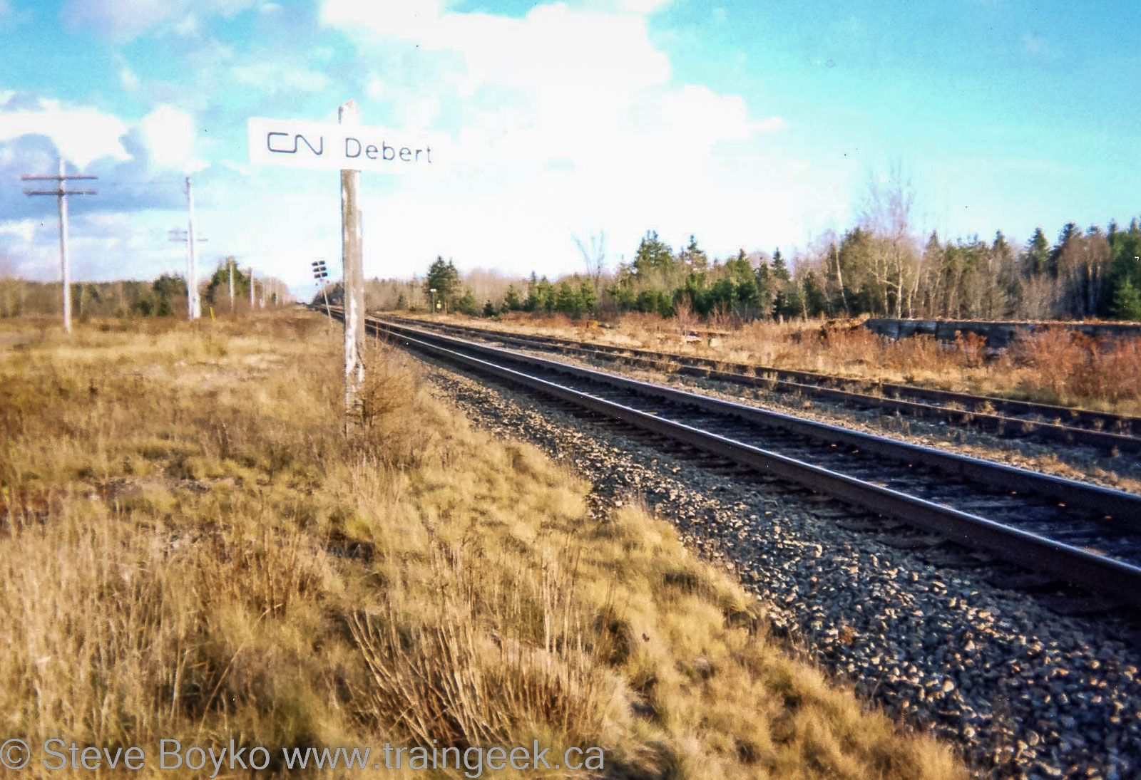
I recently constructed a loading ramp on my layout to better serve the CN team track. It was loosely modeled after a few ramps I’ve seen in the past, including the loading ramp that used to be in Debert, Nova Scotia.
These photographs were taken sometime in the early 2000s. They were taken with a film camera so I don’t have a date, but I imagine it was around 2002.
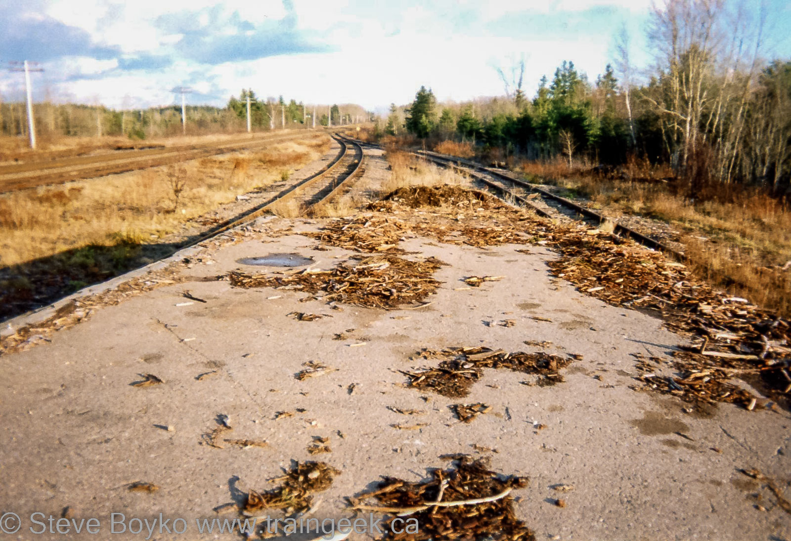
When I took the photo, there was a siding, and one track that branched off the siding toward the loading ramp. It split into two tracks, one for side loading and one for end loading. Please see the track diagram below.
Today there is no siding and no ramp; the CN Springhill subdivision rockets right through town with no switches and no stopping.
CN in Debert, April 1965
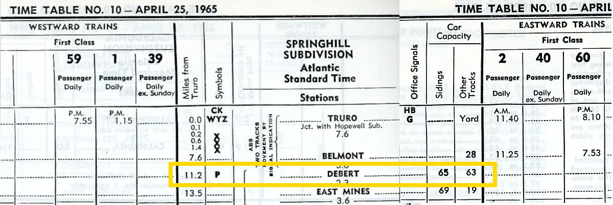
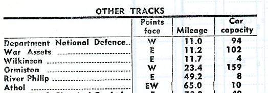
In the April 25, 1965 CN employee timetable, Debert is shown as having a 65 car siding, with 63 cars’ worth of “other tracks”. These are usually storage tracks and don’t necessarily include customer tracks.
The table below shows the “other tracks” on the subdivision, and three of them are listed in the Debert area:
- Department of National Defence, mile 11.0, 94 car capacity
- War Assets, mile 11.2, 102 car capacity
- Wilkinson, mile 11.7, 4 car capacity
Debert has an airport that was used for RAF training during World War 2, training the ferry crews that flew new aircraft across the Atlantic to England. Today it is home to the Truro Flying Club, and was where Air Cadets did glider training until the COVID-19 pandemic. In fact, my oldest son did glider training at Debert.
Debert also served the ground forces and was used by all five Canadian divisions of the First Canadian Army for staging prior to shipping out to Europe.
1965 was the last year the 31st Ordnance Ammunition Depot was based at Debert.
The 720 Communication Squadron was based at Debert until 1985, staffing one of the infamous “Diefenbunkers”. This was one of six “Regional Emergency Government Headquarters” intended to house 350 people for 90 days. Today it is privately owned – see its Facebook page.
The Royal Canadian Navy used the Debert airfield for carrier landing practice until 1968.
CN in Debert, August 1988
The August 1988 CN Car Control manual shows a lot of track in Debert at that time. There was a siding TM23 with the team track(s) off that, and on the other side of the main line, a storage track and a spur to Cooks Chick Hatchery.
These car control manuals are deceiving. It doesn’t look like a long way to TM30 and TM28, but a glance at a satellite view of Debert shows that the track off TM27 curved away to cross Plains Road and head straight north for close to a kilometre (~ 3000 feet). It looks like there is still a chicken farm there.
- TM23 – siding, 3190 feet
- TM25 – team track & side ramp, 580 feet
- TM26 – team track & end ramp, 480 feet
- TM27 – storage, 1255 feet
- TM28 – vacant, 3625 feet
- TM29 – storage, 525 feet
- TM30 – Cooks Chick Hatchery, 200 feet
A mile and a half away, the Debert Industrial Park had its own siding and spurs, although none were in use in 1988. Today one can see where the track branched off the main line. The park has a few distribution centres today.
- TM19 – Runaround track, 900 feet
- TG01 – vacant, 495 feet
- TG02 – vacant, 195 feet
- TG08 – vacant, 350 feet
- TG10 – vacant, 320 feet
CN in Debert, November 1993
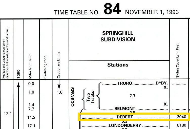
The November 1, 1993 CN employee timetable still shows a siding at Debert, with 3,040 usable feet – slightly shorter than the car control manual said. These siding lengths sometimes fluctuate depending on who measures them and what method they use to determine what part of it is “usable”. You can’t use the very ends of the sidings because a car parked there might be too close to the main track.
It pays to read the footnotes that accompany the subdivision table, because this one mentions the “Debert ballast pit spur” at mile 11.0.
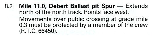
I feel that is the spur that went to “TM28” and “TM30” in the car control manual. The note about the crossing at mile 0.3 of the spur matches the distance for the Plains Road crossing from the main line.
End Tangent
I went off on a tangent researching the history of this loading ramp! I hope you enjoyed the background around Debert and its railway history.